Outdoors Club!

Henninger Flats Trail
Time at Start: 6:25 AM
Time at Destination: 7:35 AM
Time at Return: 8:35 AM

AllTrails Route: Henninger Flats Trail

Total Distance: 5.7 mi
Elevation Gain: 1,400 ft

This week in interesting trivia, hm…

  • In the context of clubs, date rape drugs are old news, but needle spiking is new to me. (To clarify, I don’t and have never gone clubbing, I’m just reading the news and Wikipedia articles.)
  • Oiling eggs and dummy eggs apparently are effective ways to control bird populations.
  • Death Valley is very hot. It’s also in California. /s
  • Death Valley is also home to the endangered Death Valley pupfish, which can withstand water that’s 4 times more salty than the ocean, and water temperatures from 0°C - 47°C / 32°C - 116°C. What a chad.
  • Bluetooth is named after King Harald “Bluetooth” Gormsson, and its logo () uses the Younger Futhark runic letters for said king’s initials: HB / ᚼᛒ.
  • Custom design bar runners (think Gamers Nexus’s bar runner and coasters) are expensive. Well, the one from this shop anyways.
  • Complained about AMD drivers, but apparently I have Stockholm Syndrome or something 'cos I’ve got RX 6950 XTs on my interest list. :pensive:
  • I don’t sing, but somehow the Neumann TLM 103, AKG C414 XLS / C414XLII, and Austrian Audio OC18 / OC16 are also now on my interest list. These mics are not cheap, but are still considered “more affordable” options (especially in the case of Neumann).
3 Likes

Henninger Flats Trail
Time at Start: 6:30 AM
Time at Destination: 7:35 AM
Time at Return: 8:25 AM

AllTrails Route: Henninger Flats Trail

Total Distance: 5.6 mi
Elevation Gain: 1,400 ft

[Noms creamsicle.]
(Blue Ribbon Orange Dream Bar, or something. Shared from roommate. :pepesaber:)


Once upon a time, 'Chew was doing derp things again and bought two packs of knock-off Klondike bars (two 'cos there being a steep discount). Each pack had 12 bars.

Thing is, 'Chew had just graduated from uni, and had about a week or so to move out from the apartment back to her place.

To avoid wasting food, 'Chew ate a bar – sometimes two – every day. Even so, on moving day, there was still a buuunch of bars left. She had to throw them all out before moving out of the apartment. It was such a waste.

Also, 'Chew got chubbier from consuming all those knock-off Klondikes.

'Chew hasn’t bought ice cream from the grocery store ever since then.

Moral of the story is, don’t be a 'Chew. :joy:

3 Likes

For the first time in a long while I went on vacation. I went to France, to two locations, both near the border of Germany (the latter close to the Swiss border too). I also went on three hikes, which I would describe as moderate difficulty for the shape I’m in.


Circulaire de l’Eselbahn

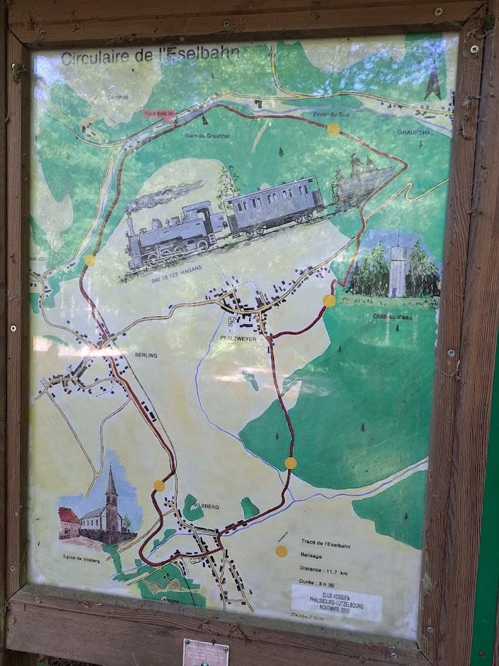
The first was ‘Circulaire de l’Eselbahn’, whose name is a combination of French and German. ‘Circulaire’ meaning ‘circular’, based on the circular shape of the track and ‘Eselbahn’ being German for ‘donkey track’.
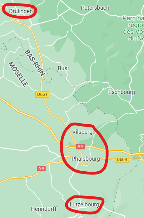
This hike is based on the 1883 built traintrack which stretch from the southern Lutzelbourg to the northern Drulingen and passed through Phalsbourg/Vilsberg:


The purpose of this traintrack was mainly to bring sandstone from Vilsberg, Bust and Hangwiller (not pictured on the map, smaller town north of Berling) to Lutzelbourg.

On the hike itself you don’t see much evidence of a traintrack on any of the track - except for some streetsigns featuring the word ‘Gare’ (the French word for ‘[train] station’).
The hike itself 11,7km (7.3 miles) with minimal height difference (about 90m/300ft elevation difference at most).


The route has a few things to see, including a water-tower and a few churches in the towns you cross.

We started this hike in Berling (center west) and walked the route clockwise (so walking north), just in case we were too tired by the time we reached Pfalzweyer (center east) we could decide to walk inbetween these two towns and cut the route short.
In the end we walked the full 11,7km route.

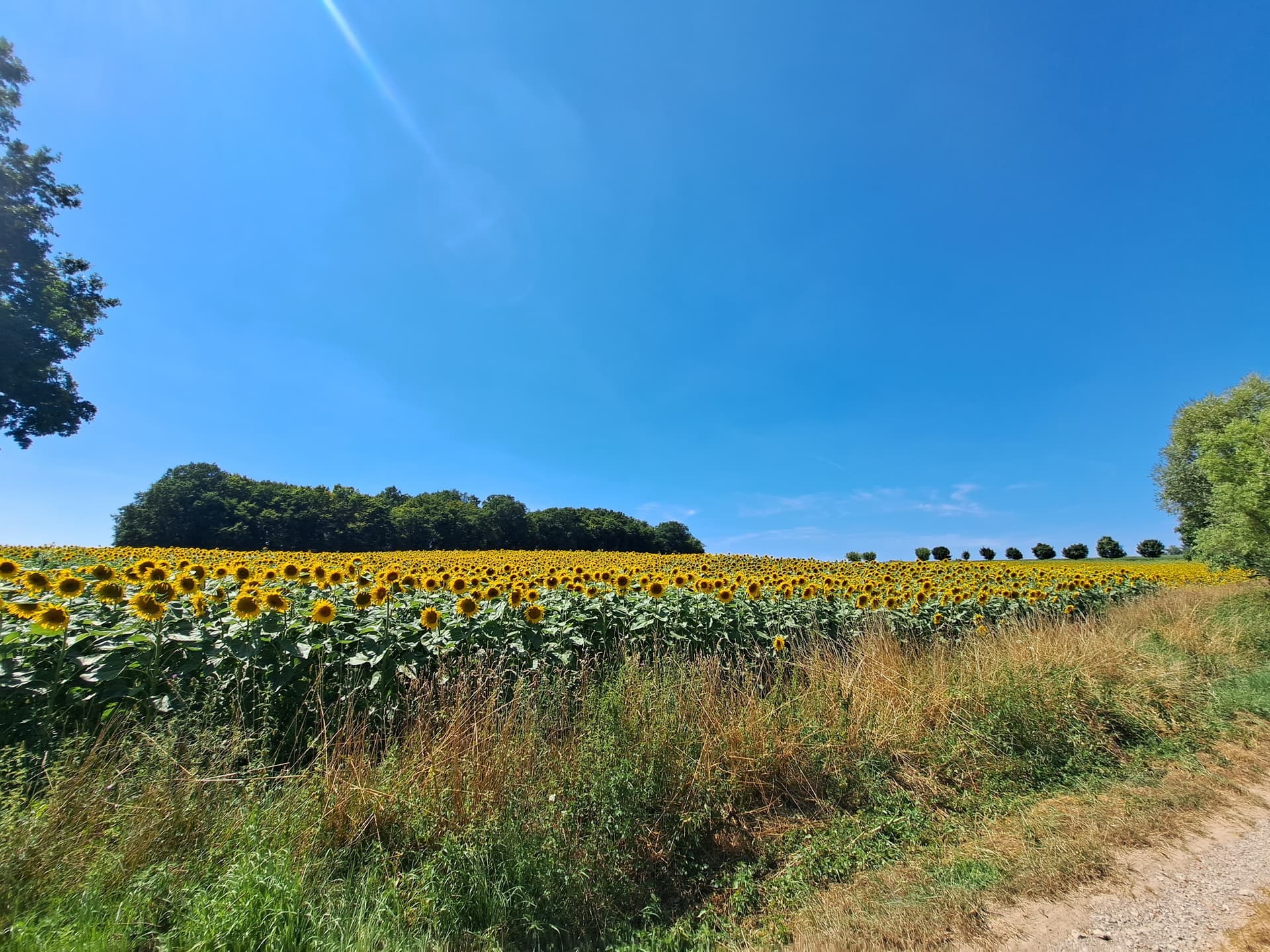
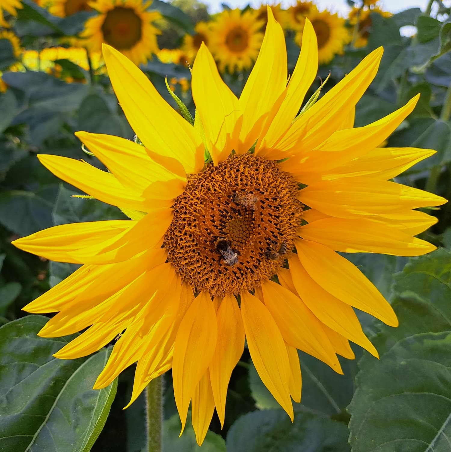
The scenery was varied and included some forest areas, but also more open field (included corn and grain fields). Among these fields we also saw a really big sunflower field:

The other hikes were in a different location, further south in France more near the Swiss border - but still near the German border too. We were in a small town just west of the French city of Mulhouse.


Circuit of Notre-Dame du Chêne and the Chêne de Saint-Louis

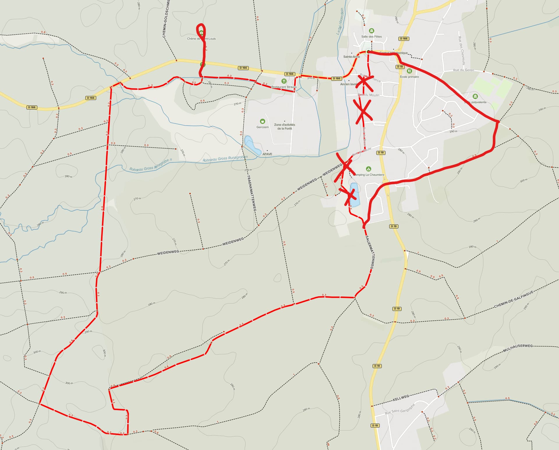
The first hike we took in this area didn’t have its own name, because I think it’s an existent route + an extension to it. The name of this hike it’s based on is “Circuit of Notre-Dame du Chêne and the Chêne de Saint-Louis” (which translates to “Circuit of the Notre Dame* of the oak tree and the oak tree of Saint-Louis” (*‘Notre dame’ literally means ‘Our Lady [Mary]’ and is a title used for many Christian churches).

The route we took was roughly 11,5km (7 miles) long with only some elevation entering the town of Heimsbrunn:


The default route + the extension on the right (roughly).
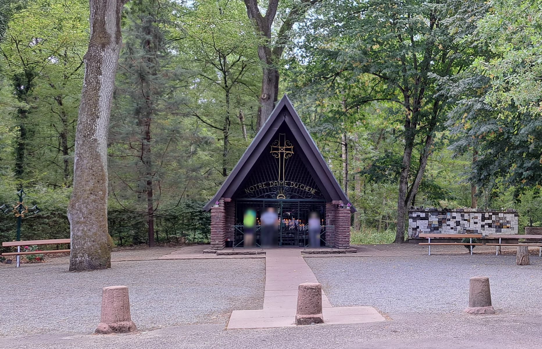
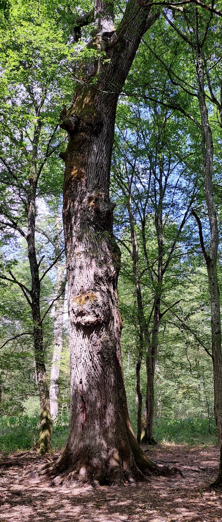
The ‘extra bit’ on the top is the walk to the (probably) 700 year old oak tree and the chapel the hike is named after.


The chapel, where people can light a candle in memory of their loved ones. The wall on the right featured room for people to place/hang a plaque in remembrance of loved ones, although both sides of the wall are completely filled.


The eponymous (for the chapel and route) 700 year old oak.


Freiburg im Breisgau

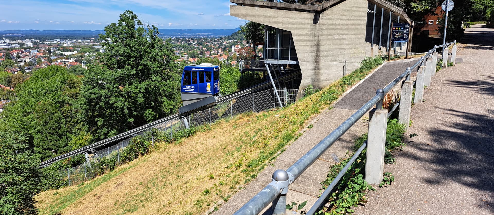
The German city of Freiburg im Breisgau is near the French border and is a pretty German city. The city is built just next to a hill (where I’m from we’d call it a mountain, at 450 meter/1500 feet tall) and they have a cable car set up to halfway up this hill.


A three minute long ride on this cablecar takes you a little over halfway up this hill

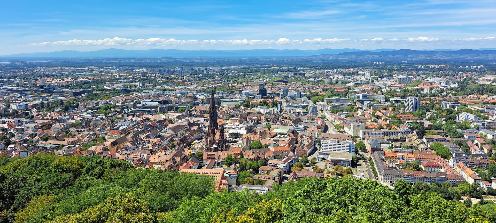
‘Schlossberg’ is German for ‘Castle hill’, because a castle was built up here in the 11th century. Little of this castle remains here today, but it does serve for a great way to look over the city.
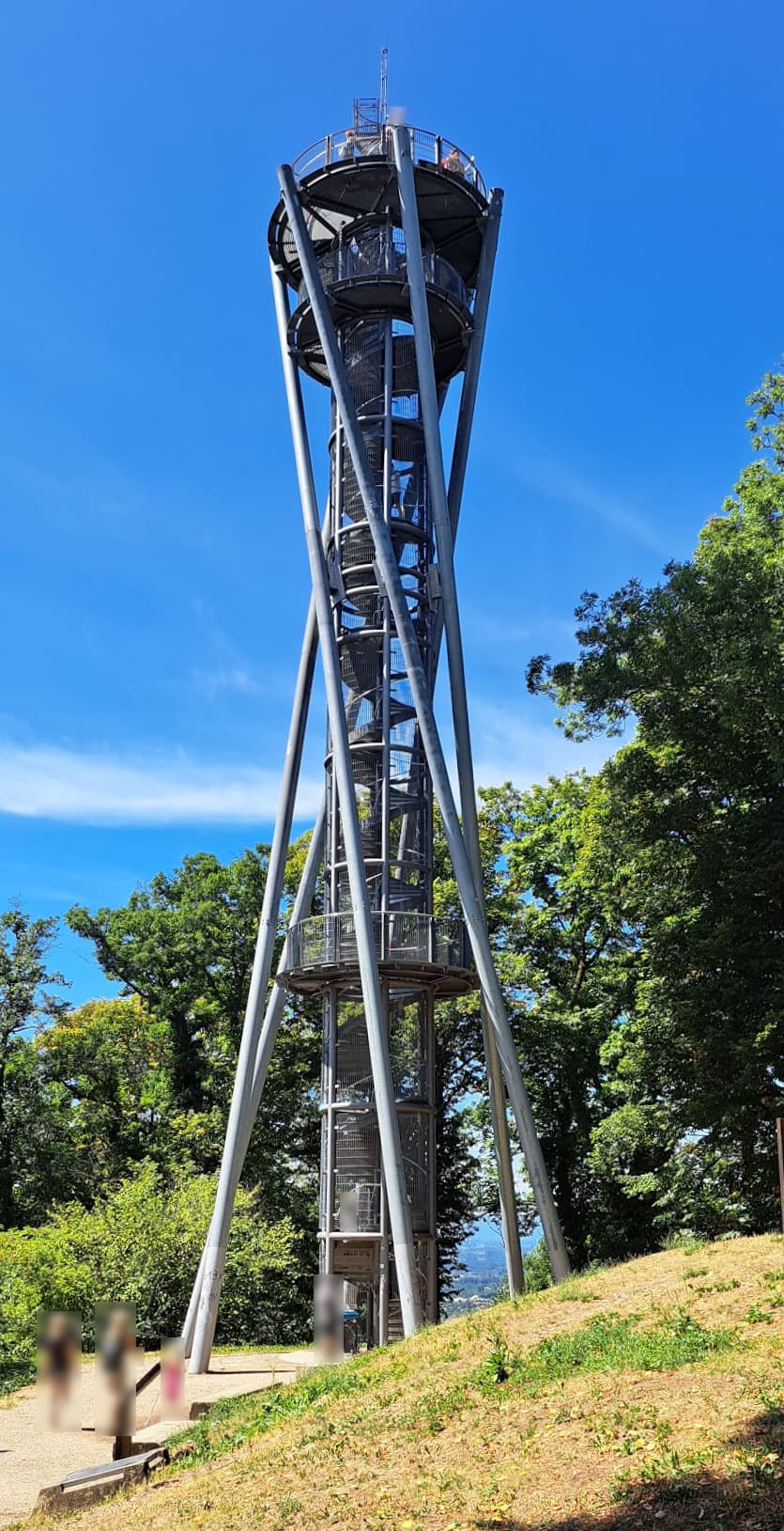
To give an even better view over the city, a 35 meter (115 feet) tall tower is placed on the top of the hill. After you get up its 153 steps (which show the names of the donors for this tower) it gives you a great view over the city, including the cathedral we had just visited prior:


At the very top the tower is quite shaky, moving about from side to side - especially if people try to do this on purpose. This movement side-to-side is by design, as the tower is reportedly able to withstand winds up to Beaufort 12 (also known as a hurricane, 118km/h or 73mph winds)


The view over the city we’ve just visited is marvelous.
This photo was taken from the top of the tower, looking westward over the city. The couple mountains just outside of the city to the right are in Germany, the mountains in the background are all the way over in France, just west of Colmar. This mountain range is called the ‘Vosges’.

The walk down as quite treacherous and I’m glad we took a cable car at least for some part of it!


Le Sentier Des Bunkers

Finally we did another hike, with a name that translates to ‘The Trail of Bunkers’. The hike started in the town of Burnhaupt-le-Bas.
While currently France and Germany are kind and cordial with each other, their past is quite dark. This region of France near the border of Germany especially had to endure a lot of nasty things.
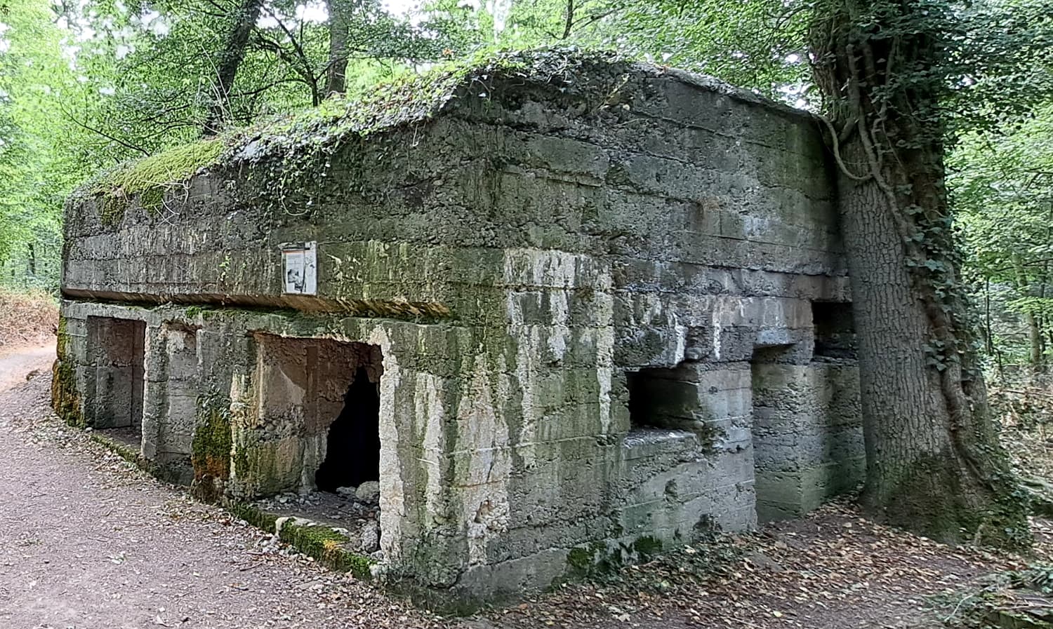
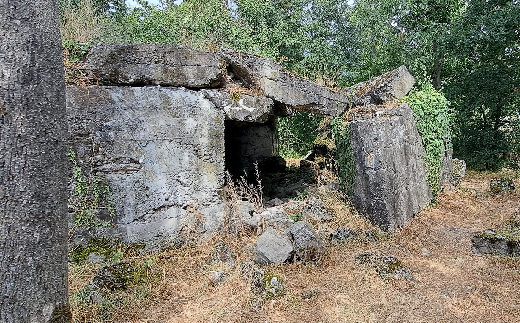
Le Sentier Des Bunkers is a hike that takes you past a dozen bunker structures - or what is left of them, as it is over 100 years since they have been used.


An example of a bunker in better condition

And one that hasn’t stood the test of time

This hike shows you a history of this region, what had to be done to properly attack, defend and resupply in a terrible war.
There are different types of bunkers which you see on this trip, including barracks, supply locations and also what is suspected to be a first aid location, due to its somewhat hidden location. Along the way you see more interesting things, such as two fishing lakes, a small dam and also a large wooden structure meant for picknicking and such (although people were camping there when we passed by).

One person reviewed this hike on Google Maps and mentioned their annoyance with ‘a permanent background noise of a highway’ (which is only nearby during a small portion of the hike) and they also mentioned their disappointment with the state of disrepair of these bunkers.
The latter complaint really annoys me, as I don’t think these buildings should be touched and changed. This is what reality is and what 100 years of a different world does. They should serve as a permanent reminder; this happened once last century and unfortunately again that same century; but never. again.

This hike was 9km/5.5 miles long, but most certainly the most interesting one I’ve done (so far).
EDIT: Oh I forgot to mention this, but I even found a ‘geo cache’ spot sort of by accident. The last bunker had some steel ladder rungs on it, allowing you to climb up it. There I saw a small black tube, which had a plastic baggy with a note in it, which people signed with their name and the date that day. I sadly didn’t have a pen with me to write something down though!

Other than the basics, I don’t know too much of World War I and the impacts it had on this region, but seeing what they had to do here certainly gave me inspiration do look into it further.

So that’s what I did this summer, pretty fun stuff!
I don’t know how to end this post, so here is a picture of a sunflower with some (bumble)bees on it:

8 Likes

Henninger Flats Trail
Time at Start: 6:40 AM
Time at Destination: 8:00 AM
Time at Return: 9:30 AM

AllTrails Route: Henninger Flats Trail

Total Distance: 5.8 mi
Elevation Gain: 1,400 ft

Went hiking with roommate today! :pepesaber:
Anyway, w/e, shoo, I wanna play Cyberpunk 2077 now.
In love with Judy. She kinda cute.

3 Likes

Mate we were 10km apart :pepog:

3 Likes

I went outside and touched grass.

4 Likes

Gabrielino Trail to Gould Mesa Campground
Time at Start: 4:25 PM
Time at Destination: 5:40 PM
Time at Return: 6:40 PM

AllTrails Route: Gabrielino Trail to Gould Mesa Campground

Total Distance: 5.3 mi
Elevation Gain: 375 ft

Generic Scenery Photos:


NASA Jet Propulsion Laboratory (JPL)
Cool beans.


Gould Mesa Campground
Campground’s larger than it looks – didn’t take other photos 'cos campers were setting up and didn’t wanna photograph 'em.

Friendos and I went for a hike last Sat!

Trail’s pretty nice, wide, and flat for the most part, though the scenery was very… dry. Lotsa sand and gravel, leaf-less bushes, and a very parched river.

Stopped at the campground and turned back, 'cos dinner. :derpdorp:
Mebbe next time I’ll hike the full route.

3 Likes

Actually Gabrielino Trail
Time at Start: 6:30 AM
Time at Destination: 8:20 AM
Time at Return: 10:00 AM

AllTrails Route: Gabrielino Trail: Jet Propulsion Laboratory to the USFS Dam

Total Distance: 9.4 mi
Elevation Gain: 1000 ft

Generic Scenery Photos:


Last Saturday’s hike! :pepesaber:

The last 1 mi of the trail is all uphill, and some bends are suuuper gravelly / loose. Very easy to lose your footing here, wouldn’t recommend hiking the last section for first-timers. Definitely bring some gloves and trekking poles.

Otherwise, the rest of the trail’s flat and shaded enough that it warrants AllTrails’s “Easy” tag, I suppose. :thinking:

Had a Philly cheesesteak after the hike. No pics, 'cos it honestly did not look photogenic, lol.
Tasted like any other regular beef sandwich. Would’ve preferred some veggies. :eyes:
InB4 I offend cheesesteak enthusiasts. :rofl:

3 Likes

Henninger Flats Trail
Time at Start: 6:20 AM
Time at Destination: 7:30 AM
Time at Return: 8:30 AM

AllTrails Route: Henninger Flats Trail

Total Distance: 5.8 mi
Elevation Gain: 1,400 ft

Generic Scenery Photos:


Henninger Flats Trail from Above
Hehe, puny humans.
Am also a puny human. :derpdorp:

Rained on Fri night, so Sat morning was very noice n’ cloudy. :partyparrot:
Cloudy’s lovely, cloudy’s great. So sick of summer.

So they keep saying “Winter is coming” but when is winter coming?

3 Likes

Henninger Flats Trail
Time at Start: 6:20 AM
Time at Destination: 7:35 AM
Time at Return: 8:30 AM

AllTrails Route: Henninger Flats Trail

Total Distance: 5.7 mi
Elevation Gain: 1,400 ft

Sat morning was nice n’ cloudy again. :blush:

Saw a bunch of runners this week, probably part of a school club.
Maaan.
青春 / Youth.

4 Likes

Henninger Flats Trail
Time at Start: 6:30 AM
Time at Destination: 8:30 AM
Time at Return: 10:00 AM

AllTrails Route: Henninger Flats Trail

Total Distance: 5.9 mi
Elevation Gain: 1,400 ft

Went hiking with roommate, got a long overdue haircut, touched grass sand.
Learned that roommate and I share similar religious, political, and social views.

Also ran into a hiking acquaintance-friend-person whom I frequently see on the trail. Apparently he went on vacation to see his family, and he bought me a gift.

It’s one o’ those mass-produced keychains with the person’s name on it. This one’s got an LCD screen with my name in gaudy print, and a Las Vegas, Nevada epoxy-metal trinket. :laughing:
Honestly, it’s not gonna see much use outside my box for random gifts n’ memorabilia, but I really appreciate the gesture.
Also my paranoia wondering whether the keychain has any sort of tracker attached to it and how I would be able to find that out.

3 Likes

Soon :tm:

1 Like

Henninger Flats Trail
Time at Start: 6:20 AM
Time at Destination: 7:30 AM
Time at Return: 8:30 AM

AllTrails Route: Henninger Flats Trail

Total Distance: 5.8 mi
Elevation Gain: 1,400 ft

Generic Scenery Photo:


Unrelated:

Sunday morning, rain is fallin’…

Saturday morning, and no rain, tho. :laughing:
I’ve mentioned this before, but Gura has a craaaaaaaaaazy lovely voice.

3 Likes

Henninger Flats Trail
Time at Start: 6:00 AM
Time at Destination: 7:15 AM
Time at Return: 8:20 AM

AllTrails Route: Henninger Flats Trail

Total Distance: 5.7 mi
Elevation Gain: 1,400 ft

Add a couple miles of walking around in office shoes, too.
Holy hell I forgot how uncomfortable they are.

3 Likes

Henninger Flats Trail - First Bench
Time at Start: 6:20 AM
Time at Return: 8:00 AM

AllTrails Route: Henninger Flats Trail

Total Distance: 3.4 mi
Elevation Gain: 650 ft

Roommate tagged along for this one, but there was a heavy drizzle today.
Cut the hike short and only reached the first bench, 'cos humid weather was dampening my roommate’s mood. He apologized profusely afterwards, even tho I kept telling him all sorts of reasons why it’s k. :sweat_smile:

No biggie, no biggie. At least we learned something from the hike. :grin:

4 Likes

Henninger Flats Trail
Time at Start: 6:00 AM
Time at Destination: 7:25 AM
Time at Return: 8:20 AM

AllTrails Route: Henninger Flats Trail

Total Distance: 5.6 mi
Elevation Gain: 1,400 ft

Generic Scenery Photos:


Los Angeles County - Early Morning


Henninger Flats Trail
Mask up, because according to facts, every coolant technically has bits of clouds in it, and it is statistically impossible that clouds don’t contain trace amounts of semen.
Don’t worry if that sentence did not make sense.


Random Wikipedia Reads:

  • Cannibalism
  • Human Cannibalism
    • Albert Fish (1870 - 1936): Murdered and tortured multiple child victims, cannibalized at least one child victim.
    • Jeffery Dahmer (1960 - 1994): Murdered and dismembered at least 17 adult victims, cannibalized at least one victim.
    • Issei Sagawa (1949 - Presently Alive): Murdered, performed necrophilia, and cannibalized one adult victim.

Er, blame Discord and my morbid curiosity? :sweat_smile:

4 Likes

Henninger Flats Trail
Time at Start: 6:20 AM
Time at Destination: 7:25 AM
Time at Return: 8:20 AM

AllTrails Route: Henninger Flats Trail

Total Distance: 5.7 mi
Elevation Gain: 1,400 ft

'nother regular hike. :grin:
Sometimes reading the news and morbid stories gets me spooked (also 'tis the month for it, lol).
Super happy that I can hike someplace that’s fairly nearby (by car), well-populated, and decently safe. Also good for those mental breaks when my mood’s sour, or when the week’s been frustrating / dreary.

In other news, November is here, and November means…
[Laaast year, I gave you my heart]
[Mariah Carey EVERYWHERE]
Thanksgiving
Mass consumer spending and hectic hours for anyone that works in retail / shipping / logistics.

Most years I’ve only got one or two things on my Black Friday / Cyber Monday list. This year, erm… I’ve got a couple of things. :sweat_smile: :pinching_hand:
I guess Capitalism’s got it’s hooks into me now. :fishing_pole_and_fish:

2 Likes

Henninger Flats Trail (First Bench) via Eaton Canyon Trail
Time at Start: 4:15 AM
Time at Destination: 5:20 AM
Time at Return: 6:20 AM

AllTrails Route: Henninger Flats via Eaton Canyon Trail

Total Distance: 5.5 mi
Elevation Gain: 900 ft

Generic Scenery Photo:

Gate was locked at 4:05 AM, so I had to start from the Eaton Canyon Trail trailhead.
Only made it to the first bench, didn’t have time to reach the top, 'cos I’ve to make time for work later this morning.

Gotta work every day this month, regular hours.
Pien.

3 Likes

Henninger Flats Trail (First Bench) via Eaton Canyon Trail
Time at Start: 4:10 AM
Time at Destination: 5:15 AM
Time at Return: 6:40 AM

AllTrails Route: Henninger Flats via Eaton Canyon Trail

Total Distance: 5.3 mi
Elevation Gain: 850 ft

Generic Scenery Photos:

Fiddled around with some phone camera settings. :derpdorp:
Somehow, stars.
Also pics came out significantly brighter compared to reality.

5 Likes

Henninger Flats Trail
Time at Start: 6:10 AM
Time at Destination: 7:15 AM
Time at Return: 8:20 AM

AllTrails Route: Henninger Flats Trail

Total Distance: 5.7 mi
Elevation Gain: 1,400 ft

Generic Scenery Photos:

Just a random, unmanned bulldozer about 900 ft above street level, no biggie.

Also this was yesterday’s hike but I was too preoccupied with reading Homestuck to post anything lmao.
Belated Happy Thanksgiving!

2 Likes